NCERT Geography Class 10 | Transport
Topic & sub-topics covered: Transport and MCQs Questions: Lifelines of National Economy (All single detail notes are exam-oriented).
We have discussed in-depth and exam-oriented pointers that can be asked in the board exam of class 10th about the “Transport” from the NCERT Geography notes for class 10th chapter 7th “Lifelines of National Economy“.
Download the NCERT Geography for Class 10th Chapter 7 Lifelines of National Economy PDF Notes
NCERT Geography Class 10th Chapter 7 – Lifelines of National Economy Notes With MCQ questions
Are you looking to enhance your understanding of India’s transport and communication systems? Download the NCERT Geography for Class 10th Chapter 7 Lifelines of National Economy PDF Notes for a comprehensive guide to the vital networks driving the country’s economy. These notes explain key concepts like transportation, trade, and the role of communication in connecting different parts of the nation. Perfect for Class 10 students preparing for exams, this PDF simplifies complex topics and boosts your learning experience. Access the essential study material now and stay ahead in your academics!
Roadways
General Overview of Roadways in India
1. Road Network:
- India has the second-largest road network in the world, totalling 62.16 lakh km (2020–21).
2. Historical Significance:
- Roadways preceded railways in India.
- Roads are easier to construct and maintain compared to railways.
Advantages of Roadways Over Railways
1. Lower Construction Costs:
- The cost of constructing roads is much lower than that of railway lines.
2. Versatility in Terrain:
- Roads can traverse dissected and undulating topography.
- They can negotiate higher gradients, such as in the Himalayan mountains.
3. Short-Distance Transport:
- It is economical to transport a small number of people or goods over short distances.
4. Door-to-Door Service:
- Provides direct access, reducing loading and unloading costs.
5. Feeder to Other Transport Modes:
- Roads link railway stations, and air, and seaports, enhancing connectivity.
Classification of Roads in India
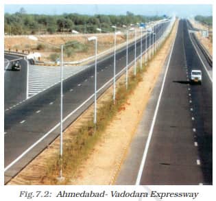
1. Golden Quadrilateral Super Highways:
- Links major cities: Delhi, Kolkata, Chennai, Mumbai via six-lane highways.
- Includes North-South Corridor (Srinagar to Kanniyakumari) and East-West Corridor (Silchar to Porbandar).
- Objective: Reduce time and distance between major cities.
- Implemented by the National Highway Authority of India (NHAI).
2. National Highways:
- Primary road systems link extreme parts of the country.
- Run in North-South and East-West directions.
3. State Highways:
- Connect state capitals with district headquarters.
4. District Roads:
- Link district headquarters with other places in the district.
5. Other Roads:
- Rural roads connecting villages and towns.
- Pradhan Mantri Grameen Sadak Yojana ensures all-season motorable roads link villages to towns.
6. Border Roads:
- Constructed and maintained by the Border Roads Organisation (BRO), established in 1960.
- Focus: Strategic importance and economic development in northern and northeastern border areas.
- Improved accessibility in difficult terrains.
Special Highlight: Atal Tunnel
1. World’s Longest Highway Tunnel:
- Atal Tunnel (9.02 km), built by BRO, connects Manali to the Lahaul-Spiti valley.
- Located in the Pir Panjal Range of the Himalayas at 3000 metres altitude.
- Open year-round, overcoming heavy snowfall restrictions.
Types of Roads Based on Material
1. Metalled Roads:
- Made of cement, concrete, or bitumen of coal.
- Suitable for all weather conditions.
2. Unmetalled Roads:
- Not durable and is less suitable for all-weather usage.
Significance of Roads
1. Strategic and Economic Importance:
- Roads in border areas improve accessibility and promote development.
- Essential for enhancing connectivity and regional growth.
2. Fast Development:
- In recent years, road networks across India have seen rapid expansion.
Railways
Significance of Railways in India
1. Principal Mode of Transport:
- Railways are the primary means for transporting freight and passengers in India.
2. Facilitation of Activities:
- Railways enable business, sightseeing, pilgrimage, and transportation of goods over long distances.
3. Integration and Economic Role:
- Railways have been a unifying force in India for over 150 years.
- They bind the economic life of the nation and accelerate industrial and agricultural development.
4. Public Sector Undertaking:
- Indian Railways is the largest public sector enterprise in the country.
Historical Development
1. First Railway Line:
- The first train in India ran between Mumbai and Thane in 1853, covering 34 km.
2. Reorganisation:
- Indian Railways is divided into 16 zones for administrative efficiency.
Factors Influencing the Railway Network
1. Northern Plains:
- Favourable conditions: Vast level land, high population density, and agricultural richness.
- Challenges: Construction of bridges across wide river beds.
2. Peninsular and Hilly Regions:
- Railway tracks are laid through low hills, gaps, or tunnels.
- Himalayan regions face obstacles like high relief, sparse population, and limited economic opportunities.
3. Unfavourable Terrains:
- Difficulties in:
a. Sandy plains of western Rajasthan.
b. Swamps of Gujarat.
c. Forested areas of Madhya Pradesh, Chhattisgarh, Odisha, and Jharkhand.
4. Western Ghats and Sahyadri:
- Railway lines cross the Sahyadri only through gaps or passes (Ghats).
Konkan Railway
1. Development:
- Facilitated passenger and goods movement along the west coast.
- Crucial for this economically significant region of India.
2. Challenges:
- Issues like track sinking and landslides have occurred in some stretches.
Role in the National Economy
1. Dominance:
- Railways are more critical to the national economy than any other transport mode.
2. Problems Faced:
- Common issues include:
a. Travel without tickets.
b. Theft and vandalism of railway property.
c. Unnecessary chain pulling causes delays and damage.
3. Suggestions for Improvement:
- Public cooperation to reduce misuse of facilities and ensure timely operation.
Pipelines
Overview of Pipeline Transport
1. Introduction:
- Pipeline transport is a relatively new addition to India’s transport infrastructure.
- Initially used to transport water, it is now used for crude oil, petroleum products, and natural gas.
2. Uses:
- Transportation of crude oil, petroleum products, and natural gas to refineries, fertilizer factories, and thermal power plants.
- Solids such as slurry can also be transported through pipelines.
3. Significance:
- Inland refineries like Barauni, Mathura, and Panipat and gas-based fertilizer plants became possible due to pipeline transport.
- Pipelines eliminate trans-shipment losses and delays.
4. Cost Efficiency:
- The high initial cost for laying pipelines, but minimal running costs afterwards.
Major Pipeline Networks in India
1. Oil Field in Upper Assam to Kanpur:
- Route: Upper Assam → Guwahati → Barauni → Allahabad → Kanpur.
- Branches:
a. Barauni to Haldia (via Rajbandh).
b. Rajbandh to Maurigram.
c. Guwahati to Siliguri.
2. Salaya (Gujarat) to Jalandhar (Punjab):
- Route: Salaya → Viramgam → Mathura → Delhi → Sonipat → Jalandhar.
- Branches:
a. Connects Koyali (Vadodara) and Chakshu.
3. Hazira-Vijaipur-Jagdishpur (HVJ) Pipeline:
- India’s first 1,700 km cross-country gas pipeline.
- Links:
a. Mumbai High and Bassein gas fields with fertilizer, power, and industrial complexes in western and northern India. - India’s gas pipeline network expanded from 1,700 km to 18,500 km.
Key Exam Takeaways
1. Advantages of Pipelines:
- Minimal running costs after installation.
- No trans-shipment losses or delays.
- Supports inland industrialization (e.g., fertilizer plants).
2. Historical Context:
- Initially used for transporting water; now expanded for oil, gas, and slurry.
3. Economic and Industrial Impact:
- Facilitates energy supply for industries, fertilizers, and power plants.
- Critical for connecting oil and gas fields to refineries and consumption centres.
Waterways
Historical Significance
1. Seafaring Tradition:
- India has been a seafaring nation since ancient times.
- Indian seamen carried and spread commerce and culture far and near.
Advantages of Waterways
1. Cost and Efficiency:
- The cheapest mode of transport, suitable for heavy and bulky goods.
- Fuel-efficient and environment-friendly.
Inland Navigation in India
1. Length and Mechanised Navigation:
- Total inland waterways: 14,500 km.
- Navigable by mechanised vessels: 5,685 km.
2. National Waterways (NW):
- Declared by the Government of India for efficient inland transport.
- NW No. 1: Ganga River (Allahabad to Haldia) – 1,620 km.
- NW No. 2: Brahmaputra River (Sadiya to Dhubri) – 891 km.
- NW No. 3: West-Coast Canal in Kerala (Kottapuram-Kollam, Udyogamandal and Champakkara canals) – 205 km.
- NW No. 4: Specified stretches of the Godavari and Krishna Rivers and Kakinada-Puducherry stretch of canals – 1,078 km.
- NW No. 5: Specified stretches of Brahmani and Mahanadi Rivers, along with Matai River and East Coast Canal – 588 km.
3. Other Inland Waterways:
- Key rivers and regions:
a. Mandavi, Zuari, and Cumberjua.
b. Sunderbans, Barak River.
c. Backwaters of Kerala.
Coastal Trade and Ports
1. Foreign Trade:
- India’s trade with foreign countries depends on ports along its coast.
- 95% of trade volume (68% in terms of value) is conducted through sea routes.
Key Exam Takeaways
1. Economic Importance of Waterways:
- Significant for bulk and heavy cargo transportation.
- Contributes to India’s foreign and domestic trade efficiency.
2. Environmental and Fuel Efficiency:
- Waterways are a sustainable alternative to road and rail transport.
Major Sea Ports
General Overview
1. Coastline and Ports:
- India has a coastline of 7,516.6 km.
- 12 major ports and 200 notified minor/intermediate ports.
- Major ports handle 95% of India’s foreign trade.
Ports on the Western Coast
1. Kandla Port (Deendayal Port):
- The first port developed post-independence.
- Built to reduce the burden on Mumbai port after the loss of Karachi port to Pakistan.
- Tidal port catering to exports/imports from Jammu and Kashmir, Himachal Pradesh, Punjab, Haryana, Rajasthan, and Gujarat.
2. Mumbai Port:
- Largest port in India.
- Features a natural and well-sheltered harbour.
3. Jawaharlal Nehru Port:
- Built to decongest Mumbai port.
- Functions as a hub port for the region.
4. Marmagao Port (Goa):
- Premier port for iron ore exports.
- Accounts for 50% of India’s iron ore exports.
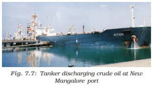
5. New Mangalore Port (Karnataka):
- Handles the export of iron ore concentrates from Kudremukh mines.
6. Kochchi Port (Kerala):
- Located at the entrance of a lagoon with a natural harbour.
- The southernmost port on the western coast.
Ports on the Eastern Coast
1. Tuticorin Port (Tamil Nadu):
- The natural harbour with a rich hinterland.
- Handles diverse cargo and facilitates trade with Sri Lanka, Maldives, and coastal regions of India.
2. Chennai Port:
- One of the oldest artificial ports in India.
- Second largest in terms of trade volume after Mumbai.
3. Vishakhapatnam Port:
- Deepest landlocked and well-protected port.
- Initially developed as an outlet for iron ore exports.
4. Paradwip Port (Odisha):
- Specialises in iron ore exports.
5. Kolkata Port:
- Inland riverine port on the Ganga-Brahmaputra basin.
- Requires constant dredging of the Hooghly River as it is a tidal port.
6. Haldia Port:
- Subsidiary to Kolkata port to reduce pressure on it.
Key Features of Indian Ports
1. Western Coast Highlights:
- Focused on iron ore and general trade.
- Natural harbours like Mumbai and Kochchi.
2. Eastern Coast Highlights:
- Rich hinterlands and trade with neighbouring countries.
- Iron ore export hubs like Vishakhapatnam and Paradwip.
Exam Takeaways
1. Importance of Ports:
- Vital for handling India’s foreign trade volume.
- Play a significant role in connecting hinterlands to global markets.
2. Strategic Developments:
- Development of ports like Jawaharlal Nehru and Haldia to reduce congestion.
- Contribution to regional and international trade.
Airways
General Characteristics of Airways
1. Fastest Mode of Transport:
- Air travel is the quickest and most prestigious mode of transport.
- It is also the most comfortable form of travel.
2. Accessibility to Challenging Terrains:
- Can cover high mountains, dreary deserts, dense forests, and long oceanic stretches with ease.
- Particularly significant for the north-eastern region, which has:
a. Big rivers.
b. Dissected relief.
c. Dense forests.
d. Frequent floods.
e. International frontiers.
3. Facilitates Access to Remote Areas:
- Air travel has greatly improved access to regions previously difficult to reach.
Role of Pawanhans Helicopters Ltd.
1. Helicopter Services:
- Provides helicopter services for Oil and Natural Gas Corporation’s offshore operations.
- Serves inaccessible areas and difficult terrains such as:
a. North-eastern states.
b. Interior parts of Jammu and Kashmir, Himachal Pradesh, and Uttarakhand.
Challenges of Air Travel
1. Not Affordable for Common People:
- Air travel is generally beyond the financial reach of the average citizen.
- Exceptions were made in the northeastern states to extend services to common people.
Significance of Airways
1. Strategic Importance:
- Crucial for connecting remote and geographically challenging areas.
- Supports industries like oil exploration in offshore locations.
2. National Connectivity:
- Plays a pivotal role in uniting different regions of the country, especially those separated by natural barriers.
Exam Takeaways
1. Unique Features:
- Fastest and most versatile mode of transportation.
- Essential for difficult terrains and emergency services.
2. Economic and Social Impact:
- Enhances access but remains a costly option for most.
- Focused efforts in northeastern states to promote inclusivity.
Communication
General Overview of Communication
1. Evolution of Communication:
- Human communication has evolved significantly, with rapid advancements in modern times.
- Long-distance communication today does not require the physical movement of either the sender or receiver.
2. Types of Communication:
- Personal Communication: Focuses on one-to-one communication.
- Mass Communication: Includes television, radio, press, and films, catering to a broader audience.
Indian Postal Network
1. Largest Postal Network in the World:
- Handles parcels and personal written communication.
2. Types of Mail:
- First-Class Mail: Cards and envelopes; airlifted using both land and air transport.
- Second-Class Mail: Includes book packets, registered newspapers, and periodicals; transported by surface mail (land and water).
3. Mail Channels:
- Six channels introduced for faster delivery in urban areas:
a. Rajdhani Channel
b. Metro Channel
c. Green Channel
d. Business Channel
e. Bulk Mail Channel
f. Periodical Channel
Digital India Programme
1. Vision:
- Prepares India for a knowledge-based transformation.
- Slogan: IT (Indian Talent) + IT (Information Technology) = IT (India Tomorrow).
2. Goal:
- Focuses on integrating technology for transformative change.
Telecommunication in India
1. Largest Telecom Network in Asia:
- Covers more than two-thirds of Indian villages with Subscriber Trunk Dialling (STD) facilities.
2. 24-Hour STD Facility:
- Uniform rate across India.
- Enabled by integrating space technology with communication technology.
3. Purpose:
- Strengthens the flow of information from grassroots to higher levels.
Mass Communication
1. Role of Mass Communication:
- Provides entertainment.
- Creates awareness about national programmes and policies.
2. Forms of Mass Communication:
- Radio:
a. All India Radio (Akashvani) broadcasts programmes in national, regional, and local languages.
b. Caters to diverse groups across the country. - Television:
a. Doordarshan is one of the largest terrestrial networks in the world.
b. Offers programmes on entertainment, education, sports, and more.
3. Print Media:
- India publishes newspapers and periodicals in about 100 languages and dialects.
- The largest number of newspapers are published in Hindi, followed by English and Urdu.
Indian Film Industry
1. World’s Largest Film Producer:
- Produces feature films, short films, and video films.
- Central Board of Film Certification certifies Indian and foreign films.
Key Takeaways
1. Economic and Social Significance:
- Communication integrates rural and urban areas.
- Plays a crucial role in education, information dissemination, and national unity.
International Trade
Definition and Types of Trade
1. Definition of Trade:
- Exchange of goods among people, states, and countries.
2. Types of Trade:
- Local Trade: Conducted within cities, towns, and villages.
- State-Level Trade: Conducted between two or more states.
- International Trade: Exchange of goods between two countries via sea, air, or land routes.
3. Market as a Trade Hub:
- Trade occurs in markets where buyers and sellers interact for exchange.
Importance of Trade
1. Index of Economic Prosperity:
- Advancement in international trade is a measure of a country’s economic development.
- Considered the economic barometer of a country.
2. Dependence on International Trade:
- No country can sustain itself without international trade due to resource limitations (space-bound resources).
Components of Trade
1. Export and Import:
- Export: Selling goods to other countries.
- Import: Buying goods from other countries.
2. Balance of Trade:
- The difference between a country’s export and import values.
- Favourable Balance of Trade: Export value > Import value.
- Unfavourable Balance of Trade: Import value > Export value.
India’s Trade Relations
1. Global Trade Partnerships:
- India has trade relations with major trading blocs and regions worldwide.
2. Export Commodities:
- Major exports from India:
a. Gems and jewellery.
b. Chemicals and related products.
c. Agriculture and allied products.
3. Import Commodities:
- Major imports to India:
a. Petroleum crude and products.
b. Gems and jewellery.
c. Chemicals and related products.
d. Base metals, electronic items, and machinery.
e. Agriculture and allied products.
India’s Role in Information Technology
1. Software Giant:
- India is a leading exporter of software products globally.
- Foreign Exchange Earnings:
a. A significant portion comes from the export of information technology services.
Tourism as a Trade
Growth and Employment in Tourism
1. Tourism Growth:
- Tourism in India has seen substantial growth over the last three decades.
2. Employment in Tourism:
- Over 15 million people are directly employed in the tourism industry.
Benefits of Tourism
1. National Integration:
- Tourism promotes unity and national integration.
2. Support for Handicrafts and Culture:
- Boosts local handicrafts and cultural pursuits.
3. International Understanding:
- Encourages global awareness of India’s culture and heritage.
Types of Tourism in India
1. Diverse Tourism Opportunities:
- Heritage Tourism: Focuses on India’s historical sites and monuments.
- Eco-Tourism: Promotes sustainable interaction with natural environments.
- Adventure Tourism: Includes trekking, mountaineering, and other adventure activities.
- Cultural Tourism: Highlights festivals, traditions, and arts of India.
- Medical Tourism: Offers advanced and affordable healthcare services.
- Business Tourism: Caters to international and domestic business travellers.
Potential and Promotion of Tourism
1. Vast Potential:
- There is immense scope for tourism development across all regions of the country.
2. Promotional Efforts:
- Ongoing initiatives are being taken to enhance various types of tourism to strengthen the industry.
Next & Previous Topics of NCERT/CBSE Political Science (Civics) Class 10 Chapter 1: Lifelines of National Economy
| Topics No. | Topics Name |
|---|---|
| 1 | Introduction To Lifelines of National Economy |
| 2 | Transport |
MCQ Questions on NCERT Geography Class 10 Chapter 7 | Transport
Question 1. Which country has the second-largest road network in the world?
a) USA
b) China
c) India
d) Russia
Answer: c) India
Question 2. What is the total length of India’s road network as of 2020–21?
a) 62.16 lakh km
b) 72.16 lakh km
c) 52.16 lakh km
d) 60.16 lakh km
Answer: a) 62.16 lakh km
Question 3. Which mode of transport preceded railways in India?
a) Airways
b) Roadways
c) Pipelines
d) Waterways
Answer: b) Roadways
Question 4. Why are roads easier to construct than railways?
a) Higher cost
b) Less terrain adaptability
c) Lower construction costs
d) Complex infrastructure
Answer: c) Lower construction costs
Question 5. What type of transport is most economical for short distances?
a) Railways
b) Roadways
c) Airways
d) Waterways
Answer: b) Roadways
Question 6. Which type of service is provided by roadways that reduce loading and unloading costs?
a) Feeder service
b) Door-to-door service
c) Long-distance transport
d) Bulk transport service
Answer: b) Door-to-door service
Question 7. What is the purpose of the Golden Quadrilateral Super Highways?
a) To connect rural villages
b) To reduce the time and distance between major cities
c) To promote tourism
d) To enhance agricultural connectivity
Answer: b) To reduce the time and distance between major cities
Question 8. Who implements the Golden Quadrilateral project?
a) Indian Railways
b) Border Roads Organisation
c) National Highway Authority of India (NHAI)
d) Ministry of Rural Development
Answer: c) National Highway Authority of India (NHAI)
Question 9. Which roads link state capitals with district headquarters?
a) State Highways
b) National Highways
c) District Roads
d) Border Roads
Answer: a) State Highways
Question 10. What is the altitude of the Atal Tunnel?
a) 2000 metres
b) 2500 metres
c) 3000 metres
d) 3500 metres
Answer: c) 3000 metres
Question 11. In which mountain range is the Atal Tunnel located?
a) Aravalli Range
b) Pir Panjal Range
c) Eastern Ghats
d) Western Ghats
Answer: b) Pir Panjal Range
Question 12. What is the principal mode of transport in India for long distances?
a) Railways
b) Roadways
c) Waterways
d) Airways
Answer: a) Railways
Question 13. When did the first train in India run?
a) 1843
b) 1853
c) 1863
d) 1873
Answer: b) 1853
Question 14. How many zones are Indian Railways divided into?
a) 12
b) 14
c) 16
d) 18
Answer: c) 16
Question 15. Which region of India is most favourable for railway development?
a) Peninsular regions
b) Himalayan regions
c) Northern Plains
d) Western Ghats
Answer: c) Northern Plains
Question 16. What is a major challenge in the construction of railways in the northern plains?
a) Sparse population
b) High relief
c) Wide river beds
d) Lack of economic opportunities
Answer: c) Wide river beds
Question 17. What was the initial use of pipelines in India?
a) Transporting crude oil
b) Transporting water
c) Transporting natural gas
d) Transporting slurry
Answer: b) Transporting water
Question 18. Which is India’s first cross-country gas pipeline?
a) Salaya-Jalandhar Pipeline
b) Hazira-Vijaipur-Jagdishpur (HVJ) Pipeline
c) Assam-Kanpur Pipeline
d) Mumbai-Pune Pipeline
Answer: b) Hazira-Vijaipur-Jagdishpur (HVJ) Pipeline
Question 19. Which river is covered under National Waterway 1?
a) Brahmaputra
b) Godavari
c) Ganga
d) Krishna
Answer: c) Ganga
Question 20. What percentage of India’s trade by volume is carried through sea routes?
a) 50%
b) 75%
c) 95%
d) 68%
Answer: c) 95%
Question 21. Which is the largest port in India?
a) Kandla Port
b) Mumbai Port
c) Chennai Port
d) Vishakhapatnam Port
Answer: b) Mumbai Port
Question 22. Which port was developed to decongest Mumbai Port?
a) Paradwip Port
b) Jawaharlal Nehru Port
c) Haldia Port
d) Marmagao Port
Answer: b) Jawaharlal Nehru Port
Question 23. What is the key feature of airways compared to other modes of transport?
a) Cheapest mode of transport
b) Most fuel-efficient
c) Fastest and most prestigious mode of transport
d) Most suitable for heavy goods
Answer: c) Fastest and most prestigious mode of transport
Question 24. Which organisation provides helicopter services for offshore operations in India?
a) Air India
b) Pawanhans Helicopters Ltd.
c) Indian Airlines
d) Directorate General of Civil Aviation
Answer: b) Pawanhans Helicopters Ltd.
Question 25. What is the vision of the Digital India Programme?
a) Rapid urbanisation
b) Knowledge-based transformation
c) Improved road connectivity
d) Enhancing tourism
Answer: b) Knowledge-based transformation
Question 26. Which channel is used for faster mail delivery in urban areas?
a) Green Channel
b) Rajdhani Channel
c) Business Channel
d) Metro Channel
Answer: b) Rajdhani Channel