Major Physiographic Divisions – Concept & Notes PDF
Topic covered: Major Physiographic Divisions and MCQs Questions: Physical Features Of India (All single detail notes are exam-oriented).
We have discussed in-depth and exam-oriented pointers that can be asked in the board exam of class 9th about the “Major Physiographic Divisions from the NCERT Geography notes for class 9th chapter 2 “Physical Features Of India“.
Download the NCERT Geography for Class 9th Chapter 2 Physical Features Of India Notes PDF
NCERT Geography for Class 9th Chapter 2 – Physical Features Of India Notes & MCQ’s Question-Answer
The chapter India – Physical Features of India introduces you to the major landforms that shape our country. From the towering Himalayan ranges in the north to the fertile Northern Plains, the rugged Peninsular Plateau, the vast Coastal Plains, the Great Indian Desert, and the beautiful Islands, each region has its own importance. These notes are designed to simplify the content of NCERT Geography Class 9 Chapter 2 and present it in a clear, student-friendly way. Download the PDF to get well-organized explanations, diagrams, and quick pointers that make revision easier and help you prepare confidently for exams.
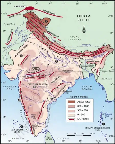
Major Physiographic Divisions
1. Classification of India’s Physical Features:
- The physical features of India are grouped into six major physiographic divisions.
- These divisions are based on relief, landform, and geographical features.
2. The Six Major Physiographic Divisions:
- The Himalayan Mountains – Young fold mountains in the north.
- The Northern Plains – Formed by river deposits (alluvium).
- The Peninsular Plateau – Oldest landmass, igneous/metamorphic rocks.
- The Indian Desert – Arid region with sandy soil and dunes.
- The Coastal Plains – Narrow strips of land along eastern & western coasts.
- The Islands – Andaman & Nicobar (Bay of Bengal), Lakshadweep (Arabian Sea).
3. Map-Based Hint:
- These six divisions can be easily identified on the Indian physical map (Figure 2.2).
- Students should practice locating and labeling all six divisions for exams.
The Himalayan Mountains
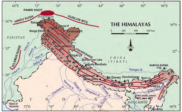
1. General Features of the Himalayas:
- Himalayas are geologically young and structurally fold mountains.
- They stretch along the northern borders of India.
- Run in a west-east direction (from Indus to Brahmaputra).
- They form an arc, about 2,400 km long.
- Width: 400 km in Kashmir, 150 km in Arunachal Pradesh.
- Altitudinal variations are greater in the eastern half than the western half.
- Represent one of the loftiest & most rugged mountain barriers of the world.
2. Longitudinal Divisions of Himalayas:
The Himalayas consist of three parallel ranges:
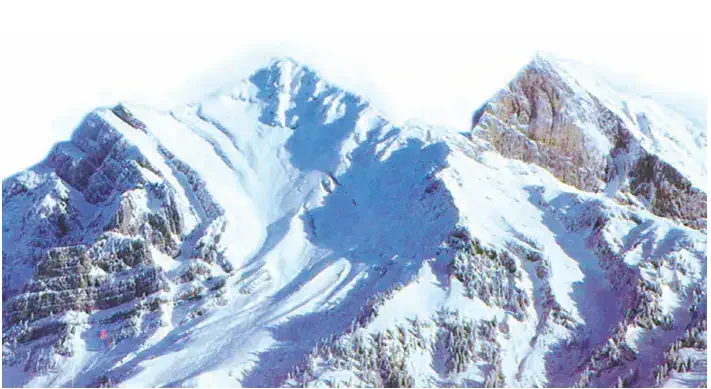
(a) The Great/Inner Himalayas (Himadri):
- Northernmost & most continuous range.
- Contains loftiest peaks (avg. height 6,000 m).
- Core composed of granite.
- Asymmetrical folds.
- Perennially snowbound with many glaciers.
(b) Himachal or Lesser Himalaya:
- Lies south of Himadri.
- Most rugged mountain system.
- Composed of highly compressed and altered rocks.
- Altitude: 3,700 – 4,500 m; Width: about 50 km.
- Pir Panjal = longest & most important range.
- Other ranges: Dhauladhar, Mahabharat.
- Important valleys: Kashmir Valley, Kangra Valley, Kullu Valley.
- Known for famous hill stations.
(c) Shiwaliks (Outer Himalaya):
- Outermost range of Himalayas.
- Width: 10–50 km; Altitude: 900–1100 m.
- Made of unconsolidated sediments (brought by rivers).
- Valleys filled with gravel & alluvium.
- Valleys between Lesser Himalaya & Shiwaliks = Duns.
- Examples: Dehra Dun, Kotli Dun, Patli Dun.
3. Regional Divisions of the Himalayas (West – East):
- Indus–Satluj – Punjab Himalaya (regionally: Kashmir & Himachal Himalaya).
- Satluj–Kali – Kumaon Himalaya.
- Kali–Teesta – Nepal Himalaya.
- Teesta–Dihang – Assam Himalaya.
- Brahmaputra = easternmost boundary of Himalayas.
4. Purvachal (Eastern Hills & Mountains):
- Located beyond Dihang Gorge – Himalayas bend sharply southward.
- Spread along eastern boundary of India (NE states).
- Formed of strong sandstones (sedimentary rocks).
- Covered with dense forests.
- Run as parallel ranges & valleys.
- Comprises: Patkai Hills, Naga Hills, Manipur Hills, Mizo Hills.
The Northern Plain
1. Formation:
- Formed by the interplay of three major river systems – Indus, Ganga, Brahmaputra (along with their tributaries).
- Made up of alluvial soil.
- Created due to deposition of alluvium in a vast basin at the foothills of the Himalayas over millions of years.
2. Extent and Area:
- Total area: about 7 lakh sq. km.
- Length: about 2400 km.
- Width: between 240-320 km.
- Population density: very high (densely populated).
3. Importance:
- Rich alluvial soil + adequate water supply + favourable climate = highly productive for agriculture.
- Known as the food bowl of India.
4. Divisions of the Northern Plain:
- Punjab Plains:
a. Formed by the Indus and its tributaries (Jhelum, Chenab, Ravi, Beas, Satluj).
b. Larger part lies in Pakistan.
c. Dominated by doabs (land between two rivers). - Ganga Plains:
a. Lies between Ghaggar and Teesta rivers.
b. Spread over Haryana, Delhi, Uttar Pradesh, Bihar, partly Jharkhand, and West Bengal. - Brahmaputra Plains:
a. Located in the eastern part of India, mainly Assam.
5. Relief Features of Northern Plains:
- Despite being mostly flat, plains have regional variations.
- Bhabar:
a. Narrow belt: 8–16 km wide, parallel to Shiwaliks.
b. Made of pebbles deposited by rivers.
c. Streams disappear here. - Terai:
a. Lies south of bhabar.
b. Wet, swampy, marshy land where rivers re-emerge.
c. Earlier thick forests, now cleared for agriculture + settlement (especially after Partition).
d. Dudhwa National Park is located here. - Bhangar:
a. Older alluvium.
b. Lies above floodplains; has terrace-like features.
c. Contains calcareous deposits (kankar). - Khadar:
a. Newer alluvium (deposited annually in floodplains).
b. More fertile than bhangar.
c. Ideal for intensive agriculture.
The Peninsular Plateau
1. General Features:
- The Peninsular Plateau is a tableland composed of old crystalline, igneous and metamorphic rocks.
- It is part of the oldest landmass, formed due to the breaking and drifting of Gondwana land.
- Physical appearance: broad and shallow valleys, rounded hills.
2. Divisions of Peninsular Plateau:
a. Central Highlands
- Location: North of the Narmada River, covering major area of Malwa Plateau.
- Boundaries:
i. South – Vindhyan Range (bounded by Satpura Range).
ii. Northwest – Aravalis. - Extension: Westwards – merges into sandy desert of Rajasthan.
- Rivers: Chambal, Sind, Betwa, Ken – flow from southwest to northeast (showing slope).
- Shape: Wider in west, narrower in east.
- Eastern extensions: Bundelkhand and Baghelkhand.
- Further east: Chotanagpur Plateau, drained by Damodar River.
b. Deccan Plateau
- Shape: Triangular landmass, south of Narmada River.
- Boundaries:
i. North – Satura Range.
ii. East – Mahadev, Kaimur, Maikal Hills. - Slope: Higher in west, slopes eastwards.
- Northeastern extension: Meghalaya, Karbi-Anglong Plateau, North Cachar Hills – separated by a fault from Chotanagpur Plateau.
- Hill Ranges (West – East): Garo, Khasi, Jaintia Hills.
3. Ghats (Edges of Deccan Plateau):
a. Western Ghats
- Location: Parallel to western coast.
- Character: Continuous – can be crossed only through passes (Thal, Bhor, Pal Ghats).
- Elevation: Higher than Eastern Ghats (avg. 900–1600 m).
- Function: Cause orographic rainfall by forcing monsoon winds upwards.
- Local names vary regionally.
- Height increases north – south.
- Highest Peaks:
i. Anai Mudi (2695 m)
ii. Doda Betta (2637 m)
b. Eastern Ghats
- Location: Stretch from Mahanadi Valley – Nilgiris (Nigiris).
- Character: Discontinuous, irregular, dissected by rivers draining into Bay of Bengal.
- Average elevation: ~600 m.
- Highest Peak: Mahendragiri (1501 m).
- Hills: Shevroy Hills, Javadi Hills (southeast).
- Hill stations: Ooty (Udagamandalam), Kodaikanal.
4. Distinct Features:
- Deccan Trap (Black soil area):
a. Origin: Volcanic.
b. Igneous rocks – weathered over time – formation of black soil. - Aravali Hills:
a. Location: Western & northwestern margins of Plateau.
b. Nature: Highly eroded, broken hills.
c. Stretch: Gujarat – Delhi in SW–NE direction.
The Indian Desert
1. Location and Extent:
- The Indian desert lies towards the western margins of the Aravali Hills.
- It forms part of the Thar Desert region.
2. Physical Features:
- It is an undulating sandy plain covered with sand dunes.
- The landscape shows two types of dunes:
a. Barchans – crescent-shaped sand dunes, covering large areas.
b. Longitudinal dunes – become more prominent near the Indo-Pakistan boundary.
3. Climate and Rainfall:
- The region receives very low rainfall (below 150 mm per year).
- It has an arid climate with low vegetation cover.
4. Drainage System:
- Streams appear only during the rainy season but soon disappear into the sand as they lack enough water to reach the sea.
- Luni River is the only large river in this region.
5. Special Note (Example-based):
- If you visit Jaisalmer, you can see a group of barchans.
The Coastal Plains
1. General Features:
- The Peninsular Plateau is flanked by narrow coastal strips.
- These strips run along the Arabian Sea (west) and the Bay of Bengal (east).
2. Western Coastal Plains:
- Location: Between the Western Ghats and the Arabian Sea.
- Character: Narrow plain.
- Divisions:
a. Konkan Coast – Northern part (Mumbai–Goa).
b. Kannad Plain – Central stretch.
c. Malabar Coast – Southern stretch.
3. Eastern Coastal Plains:
- Location: Along the Bay of Bengal.
- Character: Wide and level plains.
- Divisions:
a. Northern Circar – Northern part.
b. Coromandel Coast – Southern part. - Rivers: Large rivers form extensive deltas –
a. Mahanadi
b. Godavari
c. Krishna
c. Kaveri - Lake Chilika: An important feature of the eastern coast.
The Islands of India
1. General Information:
- India has a vast mainland plus two groups of islands.
- Island groups:
a. Lakshadweep Islands – Arabian Sea (near Kerala coast).
b. Andaman & Nicobar Islands – Bay of Bengal.
2. Lakshadweep Islands:
- Location: Close to Malabar Coast of Kerala in the Arabian Sea.
- Nature: Small coral islands.
- Earlier names: Laccadive, Minicoy, Amindive.
- Renamed: Lakshadweep in 1973.
- Area: 32 sq km (smallest union territory).
- Administrative headquarters: Kavaratti.
- Biodiversity: Rich flora & fauna.
- Pitti Island: uninhabited, has a bird sanctuary.
3. Andaman & Nicobar Islands:
- Location: Bay of Bengal, elongated chain running north to south.
- Size: Bigger, more numerous, and scattered than Lakshadweep.
- Division:
a. Andaman Islands – North.
b. Nicobar Islands – South. - Geological origin: Believed to be elevated portions of submarine mountains.
- Strategic importance: Great military and economic importance for India.
- Climate: Equatorial climate (due to proximity to equator).
- Vegetation: Thick forest cover.
- Biodiversity: Great diversity of flora and fauna.
4. Interdependence of India’s Physiographic Units (Summary):
- Mountains – Source of water and forest wealth.
- Northern Plains – “Granaries of the country”, base for early civilisations.
- Plateau – Rich in minerals, base of industrialisation.
- Coastal regions & Islands – Fishing and port activities.
- Conclusion: Each region complements the other → Together they enrich India’s natural resources & development potential.
Do You Know?
1. Active Volcano in India:
- India’s only active volcano → Barren Island, located in the Andaman and Nicobar Islands.
2. Largest Saltwater Lake in India:
- Chilika Lake → Largest saltwater lake in India.
- Location: Odisha, south of Mahanadi Delta.
3. Meaning of Doab & Punjab:
- Doab: Combination of two words –
a. Do = Two
b. Ab = Water - Punjab: Combination of two words –
a. Punj = Five
b. Ab = Water (land of five rivers).
4. Largest Inhabited Riverine Island:
- Majuli Island → Located in Brahmaputra River (Assam).
- It is the largest inhabited riverine island in the world.
Next & Previous Topics of NCERT/CBSE Geography Class 9 Chapter 2: Physical Features Of India
| Topics No. | Topics Name |
|---|---|
| 1 | Major Physiographic Divisions |
MCQs on NCERT Geography Class 9 Chapter 2 Topic – Major Physiographic Divisions
Here are the top exam-oriented MCQ-type questions on “Major Physiographic Divisions” that you should prepare for your CBSE or state board exams:
Question 1. How many major physiographic divisions does India have?
a) 4
b) 5
c) 6
d) 7
Answer: c) 6
Question 2. Which of the following is NOT a physiographic division of India?
a) The Himalayan Mountains
b) The Northern Plains
c) The Peninsular Plateau
d) The Prairies
Answer: d) The Prairies
Question 3. The Himalayas extend from which river in the west to which river in the east?
a) Ganga to Brahmaputra
b) Indus to Brahmaputra
c) Sutlej to Teesta
d) Indus to Ganga
Answer: b) Indus to Brahmaputra
Question 4. What is the total length of the Himalayas?
a) 1,200 km
b) 2,400 km
c) 3,200 km
d) 4,000 km
Answer: b) 2,400 km
Question 5. What is the average height of the Great Himalayas (Himadri)?
a) 3,000 metres
b) 4,500 metres
c) 6,000 metres
d) 7,200 metres
Answer: c) 6,000 metres
Question 6. The Himachal range is mainly composed of:
a) Granite rocks
b) Highly compressed and altered rocks
c) Sandstone
d) Limestone
Answer: b) Highly compressed and altered rocks
Question 7. Which is the outermost range of the Himalayas?
a) Himadri
b) Himachal
c) Shiwaliks
d) Purvachal
Answer: c) Shiwaliks
Question 8. What are longitudinal valleys between the Lesser Himalayas and Shiwaliks called?
a) Duns
b) Doabs
c) Khadar
d) Terai
Answer: a) Duns
Question 9. Which is the longest and most important range of the Lesser Himalayas?
a) Pir Panjal range
b) Dhaula Dhar range
c) Mahabharat range
d) Khasi Hills
Answer: a) Pir Panjal range
Question 10. The Purvachal hills include all except:
a) Patkai Hills
b) Naga Hills
c) Khasi Hills
d) Mizo Hills
Answer: c) Khasi Hills
Question 11. Which three river systems together form the Northern Plains?
a) Indus, Ganga, Brahmaputra
b) Indus, Yamuna, Teesta
c) Ganga, Yamuna, Godavari
d) Narmada, Tapi, Krishna
Answer: a) Indus, Ganga, Brahmaputra
Question 12. What is the total area covered by the Northern Plains?
a) 5 lakh sq. km
b) 6 lakh sq. km
c) 7 lakh sq. km
d) 8 lakh sq. km
Answer: c) 7 lakh sq. km
Question 13. Which section of the Northern Plain is formed by the Indus and its tributaries?
a) Ganga plain
b) Punjab plain
c) Brahmaputra plain
d) Terai plain
Answer: b) Punjab plain
Question 14. Which river plain extends between Ghaggar and Teesta rivers?
a) Punjab plain
b) Ganga plain
c) Brahmaputra plain
d) Assam plain
Answer: b) Ganga plain
Question 15. Which is the fertile younger alluvium of the Northern Plains?
a) Bhabar
b) Terai
c) Bhangar
d) Khadar
Answer: d) Khadar
Question 16. Which part of the Northern Plains contains calcareous deposits called ‘kankar’?
a) Bhabar
b) Terai
c) Bhangar
d) Khadar
Answer: c) Bhangar
Question 17. The Peninsular Plateau is mainly composed of:
a) Alluvial soil
b) Crystalline igneous and metamorphic rocks
c) Sand dunes
d) Sedimentary rocks
Answer: b) Crystalline igneous and metamorphic rocks
Question 18. The plateau north of the Narmada river is called:
a) Deccan Plateau
b) Chotanagpur Plateau
c) Central Highlands
d) Meghalaya Plateau
Answer: c) Central Highlands
Question 19. Which river drains the Chotanagpur Plateau?
a) Mahanadi
b) Godavari
c) Damodar
d) Narmada
Answer: c) Damodar
Question 20. Which hill ranges form the eastern extension of the Deccan Plateau?
a) Satpura
b) Mahadev, Kaimur, Maikal
c) Aravali
d) Nilgiris
Answer: b) Mahadev, Kaimur, Maikal
Question 21. Which is the highest peak of the Western Ghats?
a) Doda Betta
b) Mahendragiri
c) Anai Mudi
d) Nanda Devi
Answer: c) Anai Mudi (2,695 m)
Question 22. The black soil area in the Deccan Plateau is known as:
a) Khadar
b) Bhangar
c) Deccan Trap
d) Terai
Answer: c) Deccan Trap
Question 23. What is the average annual rainfall in the Indian desert?
a) 200 mm
b) 150 mm
c) Below 150 mm
d) 250 mm
Answer: c) Below 150 mm
Question 24. Which is the only large river in the Indian desert?
a) Sabarmati
b) Tapi
c) Luni
d) Chambal
Answer: c) Luni
Question 25. Crescent-shaped sand dunes in the desert are called:
a) Longitudinal dunes
b) Barchans
c) Khadar dunes
d) Plateau dunes
Answer: b) Barchans
Question 26. Which part of the western coast is called the Konkan?
a) Goa – Kerala
b) Mumbai – Goa
c) Kerala – Tamil Nadu
d) Karnataka – Kerala
Answer: b) Mumbai – Goa
Question 27. The Coromandel Coast lies along which sea?
a) Arabian Sea
b) Bay of Bengal
c) Indian Ocean
d) Laccadive Sea
Answer: b) Bay of Bengal
Question 28. Which is the largest saltwater lake in India, located along the eastern coast?
a) Sambhar Lake
b) Wular Lake
c) Pulicat Lake
d) Chilika Lake
Answer: d) Chilika Lake
Question 29. What was the former name of Lakshadweep Islands?
a) Andaman Islands
b) Laccadive, Minicoy and Amindive
c) Maldives
d) Nicobar Islands
Answer: b) Laccadive, Minicoy and Amindive
Question 30. The administrative headquarters of Lakshadweep is:
a) Minicoy
b) Kavaratti
c) Amini
d) Agatti
Answer: b) Kavaratti
Question 31. Which is India’s only active volcano located in Andaman & Nicobar Islands?
a) Narcondam
b) Barren Island
c) Car Nicobar
d) Pitti Island
Answer: b) Barren Island
Question 32. Majuli, the largest inhabited riverine island, lies in which river?
a) Ganga
b) Yamuna
c) Brahmaputra
d) Godavari
Answer: c) Brahmaputra