India’s Size – Concept & Notes PDF
Topic covered: India’s Size and MCQs Questions: India – Size And Location (All single detail notes are exam-oriented).
We have discussed in-depth and exam-oriented pointers that can be asked in the board exam of class 9th about the “India’s Size” from the NCERT Geography notes for class 9th chapter 1 “India – Size And Location“.
Download the NCERT Geography for Class 9th Chapter 1 India – Size And Location Notes PDF
Download the NCERT Geography for Class 9th Chapter 1 India – Size And Location Notes PDF for a concise, students-first summary of this foundational unit. It explains latitude and longitude, India’s continental position, extent, and neighbors with simple maps and memorable examples. Use the one-page checklist to memories coordinates, standard meridian, and border facts.
Short diagrams clarify scale and distance problems, and quick practice questions mirror board patterns. Perfect for last-minute revision or classroom recap, the PDF helps you understand why India’s size and location matter for climate, transport, and strategy – without unnecessary fluff. Download it and revise confidently.
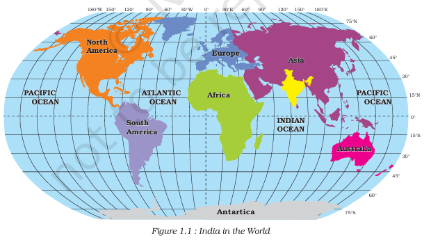
India’s Size

1. Total Area of India:
- India’s landmass = 3.28 million sq. km.
- Accounts for 2.4% of the total geographical area of the world.
2. World Ranking by Area:
- India is the 7th largest country in the world by area.
3. Boundaries:
- Land boundary of India = about 15,200 km.
- Coastline (mainland + islands) = 7,516.6 km.
4. Physiographic Boundaries:
- Bounded by young fold mountains in the north, northwest, and northeast.
5. Tapering Shape of India:
- South of 22° N latitude, India tapers and extends into the Indian Ocean.
- Divides the Indian Ocean into:
a. Arabian Sea (west).
b. Bay of Bengal (east).
6. Extent:
- Latitudinal & longitudinal extent of mainland = about 30°.
- However, east–west extent appears smaller than the north–south extent.
7. Time Lag in India:
- From Gujarat to Arunachal Pradesh = 2 hours time lag.
- Standard Time of India is taken along the Standard Meridian (82°30′ E), passing through Mirzapur (U.P.).
8. Effect of Latitudinal Extent:
- Duration of day and night varies from south to north.
Next & Previous Topics of NCERT/CBSE Geography Class 9 Chapter 1: India – Size And Location
| Topics No. | Topics Name |
|---|---|
| 1 | Location |
| 2 | Size |
| 3 | India And The World |
| 4 | India’s Neighbours |
MCQs on NCERT Geography Class 9 Chapter 1 Topic – India’s Size
Here are the top exam-oriented MCQ-type questions on “India’s Size” that you should prepare for your CBSE or state board exams:
Question 1. What is the total land area of India?
a) 3.18 million sq. km
b) 3.28 million sq. km
c) 3.48 million sq. km
d) 3.08 million sq. km
Answer: b) 3.28 million sq. km
Question 2. India’s total area accounts for what percentage of the world’s geographical area?
a) 2.0%
b) 2.2%
c) 2.4%
d) 2.6%
Answer: c) 2.4%
Question 3. India ranks as which largest country in the world in terms of area?
a) Fifth
b) Sixth
c) Seventh
d) Eighth
Answer: c) Seventh
Question 4. What is the total land boundary of India?
a) 14,200 km
b) 15,200 km
c) 16,200 km
d) 17,200 km
Answer: b) 15,200 km
Question 5. What is the total length of India’s coastline, including Andaman & Nicobar and Lakshadweep?
a) 6,516.6 km
b) 7,016.6 km
c) 7,516.6 km
d) 7,616.6 km
Answer: c) 7,516.6 km
Question 6. Which mountains bound India in the northwest, north, and northeast?
a) Old fold mountains
b) Young fold mountains
c) Plateau ranges
d) Volcanic mountains
Answer: b) Young fold mountains
Question 7. South of which latitude does India begin to taper and extend into the Indian Ocean?
a) 20° North latitude
b) 21° North latitude
c) 22° North latitude
d) 23° North latitude
Answer: c) 22° North latitude
Question 8. Which sea lies to the west of India?
a) Red Sea
b) Arabian Sea
c) Bay of Bengal
d) Mediterranean Sea
Answer: b) Arabian Sea
Question 9. Which sea lies to the east of India?
a) Bay of Bengal
b) Arabian Sea
c) Andaman Sea
d) Persian Gulf
Answer: a) Bay of Bengal
Question 10. What is the latitudinal and longitudinal extent of India’s mainland?
a) About 20°
b) About 25°
c) About 30°
d) About 35°
Answer: c) About 30°
Question 11. Despite having about 30° extent, why does India’s east-west distance appear smaller than the north-south distance?
a) Because of earth’s rotation
b) Because of tapering shape of India
c) Because longitudes converge towards the poles
d) Because of mountainous terrain
Answer: c) Because longitudes converge towards the poles
Question 12. What is the time lag between Gujarat and Arunachal Pradesh?
a) 1 hour
b) 1.5 hours
c) 2 hours
d) 2.5 hours
Answer: c) 2 hours
Question 13. Which longitude is taken as the Standard Meridian of India?
a) 81°30’E
b) 82°00’E
c) 82°30’E
d) 83°00’E
Answer: c) 82°30’E
Question 14. Through which place does the Standard Meridian of India pass?
a) Allahabad (Prayagraj)
b) Lucknow
c) Mirzapur
d) Kanpur
Answer: c) Mirzapur
Question 15. In which state is Mirzapur, through which the Standard Meridian passes, located?
a) Madhya Pradesh
b) Uttar Pradesh
c) Bihar
d) Rajasthan
Answer: b) Uttar Pradesh
Question 16. What does the latitudinal extent of India influence?
a) Temperature variation
b) Duration of day and night
c) Monsoon pattern
d) Sea currents
Answer: b) Duration of day and night

